Hachikita Kogen Scenic Walking Course
ハチ北高原パノラマウォークコース
 |
A course with several points of interest like Onuma Marshlands and Shoryuno Falls. (Slightly tougher walking course)
Route map
Route directions and land marks
- 1) Hachikita Kogen ski area parking lot
- Begin at Hachikita Kogen ski area parking lot. Enter through the asphalt road going through the ski area.
- 2) Onuma Marshlands
- 3 minutes from the parking lot there’s a T-intersection, turn right and walk for 20 minutes up the steep slope to Onuma Marshlands. A high elevation marshland at about 820m in a low basin with a landslip in the back. There is a maintained wooden walkway and you can view various mountain vegetables like Yamadori-zenmai and marsh plants like sundew. It is also an area where fireflies thrive. Around mid May a field of Muscari surround the white birch near Onuma Marshlands like a field of lavender.
- 3) Paved road
- Go down the slope along the chair lift from Onuma Marshland and merge onto the paved road, turn right.
- 4) Mizubasho no Sato
- After following the road for about 10 minutes you’ll see “Mizubasho no Sato” in the valley below the slope. Approximately 12,000 mizubasho (skunk cabbages) are planted in the unused rice fields. The flowers begin to bloom with the melting of the snows. The best time to see them is from the start of April to the end of April.
- 5) Green Park Hachikita
- Go up the hill from Misubasho no Sato via Green Park Hachikita to the entrance of the road to “Shoryuno Falls” where the road starts to slope down. There are several large boulders and the place feels like it’s from the world of Totoro.
- 6) Shoryuno Falls
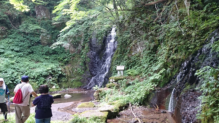
- Turn right and climb the trail along the stream from Otani River, after about 10 minutes you’ll come to “Shoryuno Falls”. Legend says that long ago a giant serpent climbed this waterfall to heaven. In the center of the waterfall is a rock that looks like a gorilla’s face and next to Shoryuno Falls is a double waterfall.
- 7) Family Ski Slope
- From Shoryuno Falls go back to the original road and backtrack about 30 minutes until you see the patrol building go to the right past the building. Walk along the woodchip trail through ski slope, once you have crossed the hill you should see end point, same as where you started.
Come and see the Zazensou a Designated Prefectural Important Cultural Property and Natural Monument, even though the cluster of Zazensou (type of skunk cabbage) can only be seen during a certain time (around the end of March).
In late March as the snows melt the purple-colored dark brown flower of the perennial herbaceous plant of the Araceae family begins to poke its head through the melting snow. The flower is said to look similar to the figure of a monk wearing zen clothes practicing Zazen (seated meditation) hence the given name Zazensou. Another name it’s called is Dharma grass, taken from the Buddhist monk Bodhidharma and the red part of the plant is not a flower but an enclosure like an altar.
- Route
- Hachikita Kogen ski area parking lot > Onuma Marshlands > Mizubasho no Sato > Green Park Hachikita > Shoryuno Falls > Hachikita Kogen ski area parking lot
- Difficulty
- ★★☆
- Route Category
- Mountain, highlands, riverside
- Type of Activity


★☆☆ Flat course(Elevation gain less than 100m)or less than 5km.
★★☆ Slightly undulating course(Elevation gain less than 500m)or less than 10km.
★★★ Rugged course(Elevation gain more than 500m)or 11km.
★★☆ Slightly undulating course(Elevation gain less than 500m)or less than 10km.
★★★ Rugged course(Elevation gain more than 500m)or 11km.
| Distance | About 5.5km |
|---|---|
| Required Time | Walking time of about 1 hour 45 minutes. |
| Starting Point | Start / End point: Hachikita Kogen ski area parking lot |
| Getting Here | By Train & Bus: From JR Yoka Station take a Zentan Bus to Hachikita (ハチ北) bus stop and get off here. By Car: Go to Hachikita Kogen ski area parking lot |
| Road Conditions | Asphalt, dirt |
| Resting Place | Public restroom: Hachikita Kogen ski area parking lot, Green Park Hachikita |
| Signpost Presence | Not Present |
| Guide Availability | Available Contact: Hachikita Tourist Association Phone: 0796-96-0732 Fee: Inquire about fees |
| Notes | This path is closed during winter (Ski resort's open season) |
| Contact | Contact: Hachikita Tourist Association Phone: 0796-96-0732 |
- Kinki Long-Distance Nature Trail - Mt. Taishi hiking course
- Nekozaki Peninsula Hiking Course
- Walk around Takeda Castle ruins and Teramachi Street
- The Famous Scenic "Kasumi Kaigan" Shiokaze Course
- Visit one of Japan's 100 most secluded regions, Torokawa Valley and Mt. Torokawa mountain trail.
- Mt. Sobu & Mt. Oosugii to Oonuka Mountain Trail
- Walking Hamasaka Town
- Yumura Onsen Course
- Moroyose Course
- Ueyama Highlands Course
- Tajima Mihonoura Course
- Home of Silkworm Culture - Osugi & Kuragaki Route
- Mining Town Walking Course in Akenobe
- View from Above the Sea of Japan - Aerial Train- Course
- Exploration of History Through Muraoka Castle Town
- Hachikita Kogen Scenic Walking Course
- Japan’s Most Beautiful Village - Tour Kami Town Ojiro & Kusube Valley Falls
- Japan’s Most Beautiful Village - Kami Town Ojiro, Giant Tree Forest, Yoshitaki Falls
- Walk Around Kuchiganaya in Ikuno Town
- Uduka History Course - Legend of the Rabbit Burial Mounds
- Uwano Nature & Interaction Forest Course
- Highland Course of a Shimmering Starry Forest and Pond
- See Oriental White Storks Dance in the Sky
- Walk the Town Where Oishi Riku Once Lived
- Along the Road Kinosaki Where Shiga Naoya Walked
- Blessings of the Earth, Walk Through the Town of Kawaminato
- Kannabe lava flow and crater course in a town where the world adventurer Uemura Naomi was born.
- A Course Through Serene Rural Landscape and a Rice Ball
- Japanese Heritage and Kitamae Ship Port "Moroyose Port" Course (Moroyose Short Course)


